Concepts
In Shelley a map is created by drawing geometries with visual styles, for example a line or polygon with a particular width or a certain colour.
Geometries
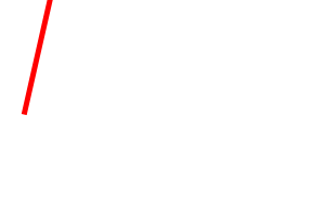
The geometries are provided by features. A feature has a dictionary of properties and a geometry. The geometry has a type and coordinates.
>>> feature.properties['road']
'motorway'
>>> feature.geometry.type
'LineString'
>>> feature.geometry.coordinates
[[20, 32.5], [43, 134]]
A sequence of features is supplied by a FeatureSource.
>>> features = data_source.features()
Styles
Styling is defined by symbolizers, which draw the geometries provided by features.
>>> from shelley import symbolizers
>>> symbolizer = symbolizers.LineSymbolizer(color='red', width=5)
Map definitions
Shelley allows alternative “mappers” for defining a map.
Mapnik Maps
One such mapper is based on the abstractions provided by the Mapnik map rendering library.
>>> from shelley.mappers import mapnik
Rules conditionally draw a list of symbolizers in order and can filter the features by their properties or only draws when the scale of the map falls within a particular range.
>>> rule = mapnik.Rule([symbolizer], filter=mapnik.Filter("[road] = 'motorway'"), max_scale_denom=500)
Styles collect rules together with a name. The rules are applied in order.
>>> style = mapnik.Style('MyRoadStyle', rules=[rule])
Layers bring styles and geometries together. The styles are applied to each feature yielded from a datasource in the order of the styles list.
>>> layer = mapnik.Layer(name='roads', data_source=data_source, styles=[style])
A map has a list of layers. The layers are drawn in order.
>>> map = mapnik.Map(layers=[layer])
Views
Common to all map mappers is the concept of the view we wish to draw.
A view of a map is defined by the area of the map to draw and an optional target spatial reference to transform to. If no spatial reference is defined then it is assumed the source geometries are all in the correct spatial reference already.
>>> import shelley
>>> view = shelley.Box(min_x=10, min_y=-10, max_x=145, max_y=80)
The view of the map can then rendered to a particular format by a renderer.
>>> shelley.render(map, view, format)